
Description
3″ Touchscreen Handheld GPS with Preloaded TopoActive Maps
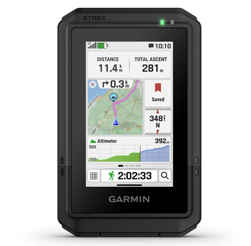
The Garmin eTrex Touch is a portable GPS navigator designed for hikers, trail runners, cyclists, and outdoor enthusiasts who require precision, durability, and ease of use in extreme conditions. With a 3″ high-resolution touchscreen, preloaded TopoActive maps, and battery life up to 130 hours in multi-band GPS mode, this device enables reliable exploration even in remote environments.
Bright Touchscreen and Intuitive Navigation
The 3″ (7.62 cm) transflective TFT color display offers 240 x 400 pixel resolution, ensuring smooth scrolling and zooming even with gloves. Transflective technology guarantees excellent readability in direct sunlight—a critical feature for outdoor navigation. The chemically-hardened glass protects the touchscreen from impacts and scratches during mountain adventures or rocky terrain exploration.
Detailed Maps and Preloaded Cartography
The device includes preloaded TopoActive maps with worldwide coverage of roads and trails, elevation contours, summits, parks, water bodies, points of interest, and thousands of specific locations. Integrated maps enable immediate navigation without additional downloads. For premium content such as satellite imagery, detailed campgrounds, and automatic Wi-Fi updates, the Outdoor Maps+ subscription is available.
Certified Durability for Every Weather Condition
The eTrex Touch meets the IP67 waterproofing standard and complies with MIL-STD-810 ruggedness specifications. This dual certification ensures reliable operation in heavy rain, fog, snow, and extreme temperatures, as well as protection from drops and impacts typical of outdoor use. The compact design (66 x 105.4 x 24.6 mm) and light weight (150 g) make it easily pocket-sized.
Extended Battery Life and Multi-Band Technology
With all satellite systems active and multi-band mode (using SatIQ technology), the device reaches up to 130 hours of battery life in standard GPS mode, and up to 650 hours in Expedition mode for extended expeditions. The rechargeable lithium-ion battery connects via USB-C for fast charging and compatibility with modern accessories.
Multi-Band and Multi-GNSS Positioning
Integrated multi-band and multi-GNSS GPS reception combines signals from GPS, GLONASS, Galileo, QZSS, BeiDou, and IRNSS, accessing multiple satellite frequencies for superior position accuracy. The barometric altimeter provides precise elevations independent of GPS reception, while the digital compass and GPS compass (in motion) ensure reliable orientation even without signal.
Intelligent Route Planning and Analysis
Connect to the Garmin Explore app on smartphone or tablet to plan routes, analyze trip data, manage waypoints, tracks, and activities. The popularity-based route calculation feature suggests the most frequently-traveled and well-established trails, while grade prediction anticipates upcoming climbs and their steepness. The round-trip itinerary automatically calculates routes that return you to the starting point within your desired distance.
Real-Time Weather Data and Geographic Information
Receive updated weather forecasts to monitor changing atmospheric conditions (requires active internet/Wi-Fi connection or synchronization with Garmin Explore app). Access sunrise, sunset, and moon phase information for planning photography or stargazing expeditions. Detailed hydrographic data includes coastlines, river and lake banks, marshes, and perennial and seasonal waterways.
Integrated Geocaching and Garmin Connectivity
Receive live updates from directly on the device via the Garmin Explore app. Cache s, logs, and hints synchronize automatically to your profile. The Garmin Share function enables easy sharing of saved positions and routes with compatible Garmin devices.
Smart Notifications and Safety Features
Receive smart notifications on the device through Bluetooth Low Energy (BLE) connection with your paired smartphone. LiveTrack transmits your position in real-time to selected contacts (requires connectivity). Night vision mode preserves night-vision capability, while Connect IQ™ support allows downloading of custom watch faces, data fields, widgets, and third-party apps.
Compatibility and Accessories
The device includes integrated Spine Mount 2 support and accepts up to 500 custom map tiles. It is compatible with the Garmin ecosystem including Garmin Connect Mobile and Garmin Explore website for data synchronization and detailed analysis. Additional accessories (straps, advanced mounts, protective cases) are available for separate purchase.
Technical Specifications
| Display | 3″ transflective TFT color (7.62 cm) — 240 x 400 pixels |
| Lens material | Chemically-hardened glass |
| Dimensions | 66 × 105.4 × 24.6 mm (2.6″ × 4.15″ × 0.97″) |
| Weight | 150 g (5.3 oz) |
| Waterproofing | IP67 |
| Impact resistance | MIL-STD-810 |
| Battery | Rechargeable lithium-ion via USB-C |
| GPS battery life | Up to 130 hours (multi-band + SatIQ) — Up to 650 hours (Expedition mode) |
| Memory | 32 GB (usable space varies depending on included maps) |
| Data interface | USB-C |
| Satellite systems | GPS, GLONASS, Galileo, QZSS, BeiDou, IRNSS (multi-band) |
| Additional sensors | Barometric altimeter, digital compass, high-sensitivity GPS receiver |
| Preloaded maps | TopoActive maps (navigable roads and trails), worldwide basemap |
| Map content | 15,000 map segments, points of interest, parks, satellite imagery (Outdoor Maps+) |
| Waypoints, routes, activities | Unlimited |
| Connectivity | Wi-Fi®, Bluetooth Low Energy (BLE), ANT® |
| Geocaching | Compatible — Geocache Live with synchronization |
| Custom maps | Up to 500 custom map tiles |
| Apps and sync | Garmin Explore (mobile and web), Garmin Connect Mobile, Connect IQ™ |
| Package contents | eTrex Touch GPS device, USB Type-C cable, documentation |
Who Should Choose the eTrex Touch
This handheld GPS navigator is ideal for hikers, trekkers, mountaineers, trail runners, cyclists, and outdoor professionals who require certified reliability, extended battery life, and detailed maps. The combination of intuitive touchscreen, certified durability (IP67 + MIL-STD-810), and multi-band multi-GNSS support makes it a dependable companion for exploration in remote areas, mountains, and extreme environments.

Reviews
There are no reviews yet.